แนวคิดโครงการ
Sense City เป็นโครงการต้นแบบเชิงทดลองโดย Future Curiosity Lab, ศูนย์การทดลองเมืองกรุงเทพมหานคร (Bangkok City Lab) ที่นำแนวคิด Ambient Computing มาใช้สำรวจบทบาทและความเป็นไปได้ในการปรับปรุงโครงสร้างพื้นฐานทางกายภาพของเมือง เพื่อสนับสนุนการสัญจรที่ปลอดภัยและเข้าถึงได้สำหรับคนทุกกลุ่ม โดยให้ความสำคัญเป็นพิเศษกับผู้บกพร่องทางการมองเห็น
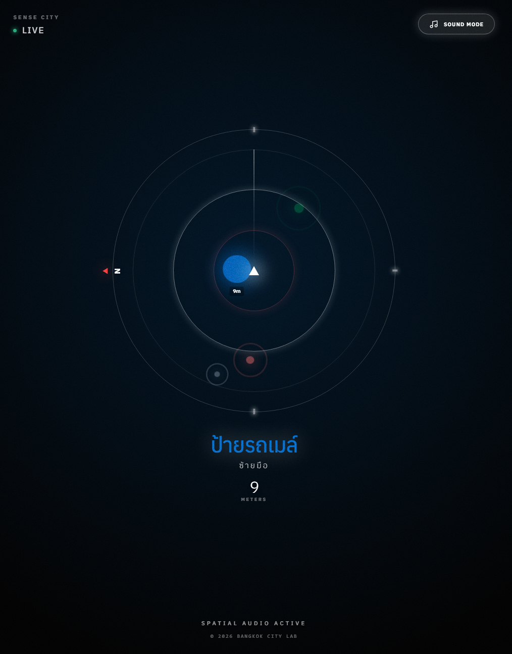
โครงการทดลองผสานเทคโนโลยีคอมพิวเตอร์วิทัศน์ (AI Computer Vision) เข้ากับเครือข่าย Bluetooth Beacons เพื่อระบุพิกัดความละเอียดสูง ข้อมูลเกี่ยวกับอุปสรรคบนทางเท้าจะถูกแปลงเป็นเสียงสังเคราะห์เชิงบรรยากาศแบบรอบทิศทาง แทนการใช้สัญญาณเตือนภัยทั่วไป แนวทางนี้มุ่งลดภาระทางการรับรู้ และทำให้การนำทางเป็นส่วนหนึ่งของประสบการณ์การเดินในเมืองอย่างกลมกลืน
นอกเหนือจากมิติทางเทคนิค Sense City ยังตั้งคำถามเชิงสังคมเกี่ยวกับบทบาทของเมืองในการดูแลความปลอดภัยและความสัมพันธ์ระหว่างผู้คน ผ่านแนวคิดการพึ่งพาอาศัยระหว่างผู้เดินทาง ผู้ดูแล และโครงสร้างพื้นฐาน โครงการนี้จึงทำหน้าที่ทั้งในฐานะการทดลองเชิงระบบ และการสำรวจกรอบความคิดใหม่ในการออกแบบเมืองที่คำนึงถึงการรับรู้ของมนุษย์
บริบทและที่มาของแนวคิด: จากงานศิลปะสู่นวัตกรรมเมือง
แนวคิดของ Sense City เริ่มต้นจากการทดลองทางศิลปะของผู้เขียนในปี 2005 ช่วงที่ทำงานออกแบบอยู่ที่นิวยอร์ก โดยได้แรงบันดาลใจจากเมืองที่ความสัมพันธ์ระหว่างมนุษย์กับพื้นที่สาธารณะมีลักษณะเฉพาะที่โดดเด่น โดยมีสมมติฐานเบื้องต้นในการมองเมืองให้เป็นระบบเสียง (Sonic System) โครงสร้างพื้นฐานและทางเท้าทำหน้าที่เป็นตัวกลาง ระบบใช้เทคโนโลยี Computer Vision วิเคราะห์การเคลื่อนไหวของผู้คนและวัตถุรอบตัว แล้วแปลงเป็นเสียงสังเคราะห์ด้วยอัลกอริทึม
ทว่าด้วยข้อจำกัดทางเทคโนโลยีในยุคนั้น ประกอบกับความเปราะบางของบริบทความมั่นคง ทำให้การติดตั้งระบบตรวจจับในพื้นที่สาธารณะเป็นไปไม่ได้ในทางปฏิบัติ แนวคิดดังกล่าวจึงดำรงอยู่เพียงในฐานะ กรณีศึกษาทางทฤษฎี (Theoretical Study) ที่รอความพร้อมของปัจจัยแวดล้อม
ปัจจุบัน เมื่อแนวคิดนี้ถูกนำกลับมาพัฒนาต่อยอดร่วมกับ Future Curiosity Lab ณ Bangkok City Lab ด้วยบริบทของเทคโนโลยี สังคม และความท้าทายที่เป็นเอกลักษณ์ของกรุงเทพมหานคร ได้กลายเป็นปัจจัยสำคัญที่เอื้อให้เกิดการเปลี่ยนผ่าน จากงานศิลปะเชิงประสบการณ์ สู่การออกแบบเพื่อการใช้งานจริง ระบบเสียงที่เคยทำหน้าที่เชิงสุนทรียศาสตร์ ถูกนำมาประยุกต์ใช้เป็นเครื่องมือระบุพิกัดและนำทาง โดยมุ่งเน้นการยกระดับความปลอดภัยในการสัญจรของผู้บกพร่องทางการมองเห็น ภายใต้เงื่อนไขของการไม่สร้างภาระทางผัสสะที่เกินความจำเป็น
แนวคิดในการออกแบบ: สุนทรียศาสตร์แทนการเตือนภัย
โจทย์หลักของการออกแบบระบบนำทางในเมือง คือการถ่ายทอดข้อมูลที่จำเป็นโดยไม่รบกวนสมาธิหรือสร้างความตึงเครียดสะสม ระบบแจ้งเตือนทั่วไปอาจใช้เสียงที่แข็งชัด หรือเสียงพูดสั่งการที่ดึงความสนใจมากเกินไป จนอาจไปกลบเสียงสภาพแวดล้อมจริงที่จำเป็นต่อความปลอดภัย
Sense City มุ่งสำรวจความเป็นไปได้ของ อินเทอร์เฟซยุคหลังสมาร์ทโฟน (Post-smartphone Interface) โดยอ้างอิงแนวคิดเทคโนโลยีที่สงบ (Calm Technology) ที่ใช้เสียงสังเคราะห์เชิงบรรยากาศเป็นสื่อกลาง ข้อมูลอุปสรรคแต่ละประเภทจะถูกแปลงเป็นเสียงที่มีลักษณะเฉพาะและปรับเปลี่ยนตามบริบท เพื่อให้การรับรู้เกิดขึ้นผ่านสัญชาตญาณ มากกว่าการตอบสนองต่อคำสั่ง
เมื่อผสานเข้ากับเทคโนโลยีเสียงรอบทิศทาง ระบบช่วยให้ผู้ใช้งานรับรู้ทิศทางและระยะห่างของวัตถุผ่านการฟัง หลักการดังกล่าวใกล้เคียงกับการสร้างการรับรู้เชิงพื้นที่ผ่านเสียง และเอื้อให้การหลบหลีกอุปสรรคเกิดขึ้นอย่างเป็นธรรมชาติ สอดคล้องกับจังหวะการเดินในเมือง


กระบวนการและเทคโนโลยี: การดัดแปลงโครงสร้างพื้นฐานเมือง
Sense City เลือกใช้ทรัพยากรของเมืองที่มีอยู่แล้ว แทนการลงทุนสร้างโครงสร้างพื้นฐานใหม่ ผ่านโมเดลการทำงานแบบ Pedestrian-to-Infrastructure (P2I)
3.1 การรับรู้ของเมือง
กล้อง CCTV สาธารณะถูกนำมาใช้เป็นแหล่งข้อมูลภาพ โดยประยุกต์เทคโนโลยี computer vision วิเคราะห์อุปสรรคแบบเรียลไทม์ เช่น สิ่งกีดขวางชั่วคราวหรือสภาพพื้นผิว ระบบประมวลผลเฉพาะข้อมูลเชิงพิกัด โดยไม่บันทึกภาพใบหน้าหรือข้อมูลระบุตัวตน
3.2 การระบุตำแหน่ง
เครือข่าย Bluetooth Low Energy (BLE) Beacons ทำหน้าที่เป็นจุดอ้างอิงตำแหน่งระดับละเอียด เหมาะกับบริบทการเดินเท้าในเมือง
3.3 การประสานและส่งข้อมูล
ระบบคลาวด์ทำหน้าที่จับคู่ข้อมูลอุปสรรคกับตำแหน่งของผู้ใช้งาน ก่อนส่งข้อมูลกลับไปยังอุปกรณ์พกพาเพื่อแปลงเป็นเสียงนำทางแบบทันที


มิติทางสังคมและการพึ่งพาอาศัย:
4.1 จากภาระของบุคคล สู่ความรับผิดชอบของเมือง
จากเดิมที่การเข้าถึงเทคโนโลยีสิ่งอำนวยความสะดวกเฉพาะทางที่มีราคาสูง (Specialized Assistive Technology) มักเป็นภาระของผู้ใช้งานส่วนบุคคล แนวคิดของ Sense City คือการเปลี่ยนโครงสร้างพื้นฐานของเมืองให้ทำหน้าที่เป็นอุปกรณ์ช่วยเหลือเสียเอง ระบบถูกออกแบบให้ทำงานร่วมกับเทคโนโลยีพื้นฐานอย่างโทรศัพท์มือถือและหูฟังทั่วไป แนวทางนี้ช่วยลดข้อจำกัดทางเศรษฐกิจ และเปลี่ยนเทคโนโลยีความปลอดภัย จากเดิมที่เป็นสินค้าส่วนบุคคล ให้เข้าใกล้ความเป็นบริการสาธารณะที่ทุกคนเข้าถึงได้ง่ายขึ้น
4.2 จากการพึ่งพาตนเอง สู่การเกื้อกูลกัน
ระบบใช้โครงสร้าง Dual Interface ที่ทำงานอยู่เบื้องหลังเพื่อรักษาสมดุลระหว่างความเป็นอิสระ และความเชื่อมโยง โดยผู้ใช้งานสามารถสัญจรได้ตามปกติด้วยอุปกรณ์ทั่วไปที่ดูกลมกลืนไปกับสังคม โดยไม่จำเป็นต้องสวมใส่อุปกรณ์ขนาดใหญ่ที่สร้างความแปลกแยก ในขณะเดียวกัน หากเกิดสถานการณ์ที่ต้องการความช่วยเหลือ ฟังก์ชัน Emergency Gesture (เช่น การกดหน้าจอค้าง) จะเปลี่ยนโทรศัพท์ให้เป็นสัญญาณภาพ เพื่อแจ้งคนรอบข้าง พร้อมกับส่งพิกัดไปยังผู้ดูแลทางไกลทันที กลไกนี้เปลี่ยนการร้องขอความช่วยเหลือให้เป็น มาตรฐานความปลอดภัยปกติ ที่เอื้อให้สังคมยื่นมือเข้ามาดูแลกันได้อย่างเป็นธรรมชาติและทันท่วงที
4.3 ข้อมูลสุขภาพเมืองแบบเรียลไทม์
ผลพลอยได้สำคัญจากการประมวลผลของ Computer Vision คือการเปลี่ยนผู้สัญจรให้กลายเป็นเซนเซอร์ที่มีชีวิต ข้อมูลอุปสรรคทางกายภาพที่ระบบตรวจพบ เช่น ฝาท่อชำรุด หรือสิ่งกีดขวางบนทางเท้า จะถูกรวบรวมและระบุพิกัดโดยอัตโนมัติ ช่วยให้หน่วยงานเมืองได้รับข้อมูลที่แม่นยำเพื่อการเข้าจัดการแก้ไขปัญหาได้อย่างรวดเร็ว นอกจากนี้ ความเปลี่ยนแปลงของเสียงสังเคราะห์ในแต่ละพื้นที่ยังเปรียบเสมือนดัชนีชี้วัดความสะดวกสบายของเมือง พื้นที่ที่มีเสียงดนตรีสงบเงียบ สะท้อนถึงทางเท้าที่มีคุณภาพและปลอดภัย ในขณะที่พื้นที่ที่มีการแจ้งเตือนหนาแน่นและซับซ้อน สะท้อนถึงความเร่งด่วนในการปรับปรุงเชิงโครงสร้าง ข้อมูลเสียงจึงทำหน้าที่สะท้อนสุขภาพของเมืองในมิติที่สัมผัสได้

สถานะปัจจุบันและทิศทางต่อไป:
ปัจจุบัน Sense City อยู่ในขั้นตอนการศึกษาและทดลองในสภาพแวดล้อมห้องปฏิบัติการ (Technology Readiness Level: TRL 4) โดยมุ่งเน้นการบูรณาการเทคโนโลยีที่เข้าถึงได้ทั่วไป เพื่อพิสูจน์แนวคิดการทำงานร่วมกันระหว่างระบบประมวลผลและโครงสร้างพื้นฐาน
โครงการยังคงสถานะเป็นต้นแบบเชิงทดลอง (Experimental Prototype) เพื่อสำรวจความเป็นไปได้ทั้งในเชิงเทคนิคและเชิงสังคม ในระยะถัดไป การพัฒนาจะมุ่งสู่การทดสอบในสภาพแวดล้อมกึ่งจริง พร้อมทั้งขยายกรอบการออกแบบไปสู่การรับรู้ผ่านประสาทสัมผัสที่หลากหลาย เพื่อศึกษาบทบาทของการรับรู้ต่อประสบการณ์การใช้ชีวิตในเมืองอย่างรอบด้าน

Sense City: Tuning the Invisible Infrastructure
Sense City is an experimental research prototype exploring the potential of ambient computing to support safer, more inclusive pedestrian movement. The project investigates how urban infrastructure can function as a subtle navigational layer, with a specific focus on the experience of visually impaired pedestrians.
At its core, the system translates environmental data—such as obstacles, surface conditions, and spatial changes—into generative spatial sound. Instead of relying on explicit alarms or spoken commands, Sense City utilizes intuitive audio cues designed to coexist with the natural act of walking. Operating as a post-smartphone interface, the project posits that navigation can be effectively guided by human sensitivity to rhythm, direction, and tone, reducing the cognitive load typically associated with screen-based assistive technologies.
Context & Rationale: From Artistic Concept to Urban Prototype
This project stems from the author’s personal exploration initiated in New York City in 2005, inspired by the potential to transform the city into a responsive soundscape. While the artistic intent was clear, the practical implementation was not feasible at the time due to technological and security constraints. Preserved as a theoretical study, it now serves as the foundation for the current prototype.
Revisited today at Bangkok City Lab, the initiative has shifted from artistic expression to inclusive urban design. Sound, once explored for its aesthetic qualities, is now applied as a functional medium for orientation.
Technical Approach: Retrofitting Urban Infrastructure
Sense City adopts a retrofitting strategy. Instead of requiring new large-scale infrastructure, the system leverages existing assets: public CCTV cameras serve as environmental sensors via computer vision, while Bluetooth Low Energy (BLE) beacons provide micro-location awareness. This data is processed as anonymous metadata, reflecting a strict commitment to privacy.
Social Dimension & Interdependence
Fundamentally, Sense City seeks to shift the burden of technology from the individual to the city. By delivering audio feedback through standard mobile devices, the project eliminates the need for costly specialized hardware, ensuring that safety is provided as an accessible public service rather than a private expense.
Beyond technology, the project proposes a social model of interdependence. The system features a dual-interface design, allowing pedestrians autonomy while maintaining a digital link to caretakers via a monitoring dashboard. Furthermore, the data collected acts as living sensors, providing urban planners with real-time feedback on infrastructure health.
Status & Future Outlook
Currently at Technology Readiness Level 4 (Lab Prototype), Sense City is not presented as a finished commercial solution, but as a platform for inquiry. It invites a broader conversation on how cities might quietly support human perception, ensuring that future urban environments are not just smart, but also empathetic.
Appendix A: The Choice of Technology (Prototyping Strategy)
The development of the Sense City prototype prioritizes Design Philosophy and Human Perception over technical complexity. By utilizing standard web technologies (TypeScript and Web Audio API), the project adopts a strategic approach that views technology as a means to an end, rather than the core objective.
Immediate Accessibility:
Operating within a standard mobile browser allows users to access the system instantly via a web link. This removes the friction of app installations, keeping the technology as approachable as possible.
Broad Compatibility:
The Web Audio API is a global standard that works on almost any smartphone, from entry-level models to high-end devices. This ensures that safety features are accessible to everyone, regardless of their hardware.
Rapid Iteration:
A web-based approach allows us to refine audio algorithms and the user experience in real-time. This flexibility enables the project to evolve quickly based on direct feedback and real-world observations.
Appendix B: The Sound of Safety
In designing an alert system that avoids triggering panic, the challenge was to find a frequency spectrum that does not compete with the existing urban soundscape—especially in a city already saturated with jarring digital warnings. The sound design rests on three creative principles:
1. Musical Harmony as Safety
The system's auditory vocabulary is restricted to the Eb Major Pentatonic scale, ensuring that when multiple obstacles trigger alerts simultaneously, the sounds form harmonious chords rather than dissonance.
The frequency spectrum spans three registers:
- Sub-bass (38–65Hz): Major physical obstacles
- Lower-mid (155–261Hz): Pathways and surfaces
- Upper-mid (622–1046Hz): Points of interest
This distribution strategically avoids the 300–600Hz range, the fundamental bands of human speech and vehicle resonance, to prevent auditory masking and ensure pedestrians remain fully aware of their surroundings.
// Core Audio Engine: Harmonic Frequency Map
// Scale: Eb Major Pentatonic (Eb, F, G, Bb, C)
// Constraint: Restricting notes to this scale ensures that overlapping
// alerts create a chord.

const SCALE_FREQS = {
LOW: [38.89, 43.65, 48.99, 58.27, 65.41], // Sub-bass (Major Obstacles)
MID: [155.56, 174.61, 196.00, 233.08, 261.63], // Lower-mid (Pathways)
HIGH: [622.25, 698.46, 783.99, 932.33, 1046.50] // Upper-mid (POIs)
};
2. Spatial Positioning (HRTF Panning)
Instead of providing verbal commands like 'obstacle at two o'clock,' the sound is designed to physically manifest from the obstacle's actual location. By utilizing Binaural Audio Positioning—a psychoacoustic principle humans use naturally to navigate space—the system allows for an intuitive sense of orientation. Direction is felt instinctively, aligning the technology with innate sensory cues.
// Real-time Spatial Calculation
// Converting GPS bearing into 3D Audio Coordinates

update(blip: RadarBlip) {
    // Convert angle to radians
    const rad = (blip.angle * Math.PI) / 180;

    // Calculate 3D position vector
    const x = Math.sin(rad) * blip.distance;
    const z = -Math.cos(rad) * blip.distance;

    // Apply to Web Audio PannerNode (HRTF Model)
    // The sound source moves relative to the user's head
    this.panner.positionX.setTargetAtTime(x, this.ctx.currentTime, 0.2);
    this.panner.positionZ.setTargetAtTime(z, this.ctx.currentTime, 0.2);
}
3. The Heartbeat Effect
As an object approaches, the sound’s rhythm accelerates, and its timbre brightens, mimicking a racing pulse during moments of heightened focus. This creates an instinctive sense of urgency that bypasses the need for explicit, stressful alarms. It leverages a biological response to proximity, providing a subtle warning that evolves with the situation.
// The 'Heartbeat' Scheduler
// Modulates rhythm and timbre based on physical proximity

scheduler() {
    // Normalize distance: 0.0 (Immediate) to 1.0 (Max Range)
    const normDist = Math.max(0, Math.min(1, this.distance / MAX_RADIUS));
    const proximity = 1 - normDist;

    // 1. Rhythmic Acceleration
    // Far: Slow pulse (2.0s) | Close: Rapid alert (0.15s)
    let interval = 0.15 + (normDist * 1.85);

    // 2. Timbre Modulation (Low-pass Filter)
    // As object approaches, the sound opens up and becomes 'brighter'
    filter.frequency.setValueAtTime(100 + (proximity * 800), time);

    // Schedule next note
    this.nextNoteTime += interval;
}
The result is an Ambient Audio Layer—a digital overlay that coexists with the city's natural pulse rather than competing against it.
Project Team & Acknowledgements:
This project is a collaborative effort within Bangkok City Lab.
- Project Lead: Bangkok City Lab
- Concept, Design & Development: Future Curiosity Lab